What is LiDAR and how does it work?
Introduction
LiDAR (Light Detection and Ranging) is an advanced remote sensing technology used to measure distances to the Earth’s surface or objects on it, creating detailed 3D maps. From aerial cityscape mapping to forest monitoring and autonomous vehicle navigation, LiDAR has become a vital tool across multiple industries, including geospatial applications. This article explores what LiDAR is, how it works, its different types, and its extensive uses in geospatial mapping.
What is LiDAR?
LiDAR is a remote sensing method that uses laser pulses to measure distances between the sensor and objects with extreme precision. By emitting a laser pulse and detecting its reflection, LiDAR calculates the “time of flight” (ToF) to determine distances and generate highly detailed “point clouds,” which form 3D models of the Earth’s surface, with or without objects.
In geospatial applications, different 3D data models are commonly used:
- DEM (Digital Elevation Model): Represents the Earth’s surface without natural (e.g., trees) or built (e.g., buildings) features.
- DSM (Digital Surface Model): Includes both the Earth’s surface and all objects above it.
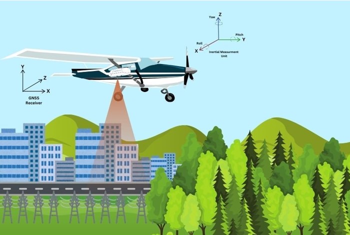
A LiDAR system consists of three main components:
- Laser scanner: Emits and receives laser pulses.
- GNSS (Global Navigation Satellite System): Determines the sensor’s precise location and movement.
- IMU (Inertial Measurement Unit): Records the orientation of the laser scanner.
Together, these components enable LiDAR to produce accurate, three-dimensional representations of the environment.
Most common types of LiDAR sensors
LiDAR sensors are categorized based on their deployment platform and application. The two primary types are airborne and terrestrial LiDAR.
- Airborne LiDAR
Mounted on aircraft, helicopters, or drones, airborne LiDAR is ideal for large-scale mapping and environmental monitoring. It includes:
- Topographic LiDAR: Uses near-infrared lasers to map land surfaces, creating 3D models for urban planning, forestry, and geodetic surveys.
- Bathymetric LiDAR: Uses green lasers to penetrate water, measuring underwater features such as seafloor depth and shoreline elevations, crucial for coastal mapping and hydrographic surveys.
- Terrestrial LiDAR
Used on ground-based platforms, terrestrial LiDAR is essential for infrastructure analysis, construction planning, and archaeology. It includes:
- Mobile LiDAR: Mounted on vehicles such as cars, trains, or boats, it scans roads, railways, and urban environments, often integrating cameras and GNSS.
- Static LiDAR: Placed on tripods, this type provides high-precision 3D scanning of stationary objects, making it ideal for indoor mapping, engineering, mining, and heritage preservation.
Each type plays a key role in different industries, generating accurate spatial data for a variety of applications.
How LiDAR works
LiDAR operates on a straightforward principle: it emits laser pulses toward a target surface and measures the time taken for the reflected light to return. This Time of Flight (ToF) calculation determines distances using the formula:
Distance = (Speed of Light × Time Elapsed) / 2
Depending on the sensor, LiDAR can emit millions of pulses per second. Each returning pulse generates a single point in 3D space, forming a point cloud that creates highly accurate digital models. These models are widely used in topographic mapping, urban planning, forestry, and autonomous vehicle navigation.
What is LiDAR used for?
LiDAR is widely applied across various industries for high-precision mapping, object detection, and environmental analysis.
Geospatial applications:
- Topographic Mapping – Creating accurate elevation models.
- Land Surveying – Providing precise 3D data for construction and development.
- Urban Planning – Assisting in infrastructure projects.
Other Key Applications:
- Forestry & Agriculture – Assessing vegetation density, monitoring crop health, and managing forests.
- Transportation & Infrastructure – Mapping roads, bridges, and railways for maintenance, expansion, and autonomous navigation.
- Environmental Monitoring – Tracking coastal erosion, glacier movements, and flood-prone areas.
- Powerline & Utility Inspections – Detecting vegetation encroachments and assessing infrastructure conditions.
- Archaeology & Cultural Heritage – Revealing hidden structures beneath dense vegetation and aiding historical site preservation.
Conclusion
LiDAR is a powerful technology that enables precise and efficient 3D mapping of the environment. Its ability to provide high-resolution spatial data has transformed industries such as geospatial mapping, transportation, environmental monitoring, and archaeology. As technology advances, LiDAR is set to play an even greater role in shaping the future of data collection and analysis.