LiDAR vs Photogrammetry
Introduction
LiDAR and photogrammetry are two widely used technologies for generating 3D maps and models and perform deep Geospatial analytics of surface and objects on it. While they work in different ways – LiDAR uses laser beams, and photogrammetry uses photos – they’re not competing technologies. In fact, they often work best together. Each one has its own strengths, and when used side by side, they can give a much more complete and accurate view of the world. This article explains how both technologies work and what makes them useful.
What is photogrammetry?
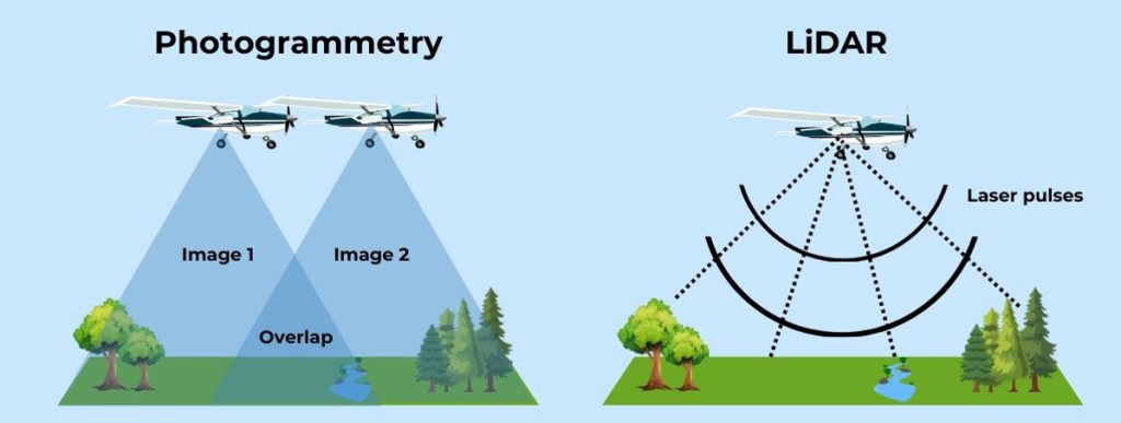
Photogrammetry is the science and technology of obtaining reliable information about physical objects and the environment through the process of capturing, measuring, and interpreting photographic images. It primarily relies on overlapping images taken from different angles, which are then processed using specialized software to reconstruct 3D surface models and maps or Orthophotographic maps.
Photogrammetry can be performed using aerial drones, light and heavy aircrafts or satellites. It operates on the principle of triangulation, whereby multiple overlaping images are analyzed to determine depth information and spatial relationships. This method is commonly used in applications such as topographic mapping, architecture, archeology, power lines or gas corridor mapping, and even virtual reality.
One of the key advantages of photogrammetry is its ability to generate detailed colorized 3D or 2D data models with rich textures (for example: 3D mesh). As it relies on standard RGB cameras, it is relatively more cost-effectivemethod compared to LiDAR. However, photogrammetry is highly dependent on enviroment brightness and other metrological conditions such as clouds, rain, fog or snow, and technical camera parameters which impacts image quality, and at the end can impact final result. This method also struggles with featureless surfaces such as water or dense vegetation.
What is LiDAR?
LiDAR, short for “Light Detection and Ranging,” is a remote sensing technology that measures distances by emitting laser pulses and calculating the time it takes for the reflected light to return to the sensor. It is used in aerial, terrestrial, and even bathymetric applications.
Unlike photogrammetry, LiDAR operates independently of ambient lighting and performs reliably in cloudy or rainy conditions, making it an ideal choice for use in virtually any environment. It excels in penetrating dense vegetation, allowing surveyors to obtain detailed ground elevation data even in forested areas. LiDAR is frequently used in fields such as topographical mapping, archaeology, forestry, autonomous vehicles, and infrastructure planning
Despite its advantages in accuracy and vegetation penetration, LiDAR is generally more expensive due to the high cost of laser scanning equipment. Additionally, while it provides highly accurate elevation data, the resulting point cloud lacks the color and texture information that photogrammetry naturally captures.
That’s why it’s very useful to use LiDAR and photogrammetry together. LiDAR gives very accurate shape and elevation data, while photogrammetry provides detailed color and texture from photos. When you combine them, you get data that is both precise and easy to understand visually. This helps create colored point clouds and realistic 3D models, making it easier to analyze and work with the information in many different fields.
Similarities and differences between LiDAR and photogrammetry
Photogrammetry and LiDAR are two distinct technologies used for 3D mapping and modeling. While they share common applications, they operate using different principles and methodologies. Understanding their differences can help determine the best technology for specific needs.
Key differences:
Data collection method
- Photogrammetry uses standard cameras to capture multiple overlapping images, which are then processed to create 3D models.
- LiDAR uses laser pulses to measure distances and generate a 3D point cloud.
Accuracy & performance
- Photogrammetry provides good accuracy but can be affected by meteorological conditions, image quality, and surface texture.
- LiDAR is generally more precise, especially in complex terrains or areas with dense vegetation, as it can collect data in almost any environmental conditions.
Cost & accessibility
- Photogrammetry is more cost-effective since it uses regular cameras and drones, making it accessible to many users.
- LiDAR is more expensive due to the specialized laser equipment required.
Color & texture
- Photogrammetry naturally captures color and textures, producing visually detailed models.
- LiDAR provides only geometric data, requiring additional processing to add realistic textures.
Shared characteristics:
- Both methods are used to create high-resolution 3D models of terrain, buildings, infrastructure, vegetation, and other physical features.
- Both technologies rely on remote sensing and can be used in aerial and ground-based applications.
- Both require specialized software for processing raw data into usable 3D models and maps.
- Both are widely used in industries such as surveying, engineering, construction, and environmental monitoring.
By recognizing the strengths and limitations of each technology, professionals can make informed decisions on which method best suits their project requirements.
Real-World applications of Photogrammetry and LiDAR
From infrastructure development to environmental management, photogrammetry and LiDAR are redefining how we capture, analyze, and interact with the physical world. These technologies are often used in tandem – offering enhanced accuracy, depth, and context to spatial data. Yet, each also brings unique strengths to the table.
In sectors such as construction, surveying, urban planning, and disaster response, both technologies provide critical data for decision-making. LiDAR offers precise elevation models and surface geometry, while photogrammetry adds rich visual context through high-resolution imagery. When combined, they deliver a comprehensive 3D view – both technical and visual.
Where LiDAR Excels
LiDAR is the preferred choice when accuracy, vegetation penetration, or nighttime data collection is essential. It enables detailed topographic mapping, forest canopy analysis, and utility infrastructure monitoring with centimeter-level precision – making it essential for engineers, environmental scientists, and civil authorities.
Where Photogrammetry Shines
Photogrammetry brings unmatched texture, color detail, and cost-efficiency. It’s ideal for architectural documentation, cultural heritage preservation, and real estate visualization. Its accessibility and portability make it especially valuable for rapid deployment in post-disaster assessments and smaller-scale mapping projects.
Main applications where both methods are used is Topographical and Orthophoto mapping, Archaeology, utilities asset management and inspections, construction site preservation, forestry and others, where detailed high precision data is crucial for decision making relied on precise data.
Which technology to choose ?
Choose photogrammetry when:
- Cost-effectiveness is a priority, and high-end accuracy is not required.
- You need visually detailed, colorized 3D models with textures.
- Working in well-lit environments where lighting is not an issue.
- Surveying or mapping large areas where high-resolution images can provide sufficient detail.
- Creating digital twins, architectural models, or heritage preservation.
- Processing can be done over time, and real-time results are not necessary.
Choose LiDAR when:
- High accuracy and precision are required, especially in elevation mapping.
- Working in environments with dense vegetation, where photogrammetry struggles.
- Operating in low-light conditions or needing data collection at night.
- Mapping terrain with sharp elevation changes, such as mountainous regions.
- Conducting detailed forestry analysis, environmental monitoring, or infrastructure assessment.
- Real-time or near real-time processing is required, such as in autonomous vehicle navigation.
Conclusion
Both photogrammetry and LiDAR offer valuable solutions for 3D mapping and spatial data collection. While photogrammetry is cost-effective and ideal for visual models, LiDAR excels in precision and penetration capabilities. Understanding their strengths and weaknesses allows professionals to select the most suitable technology for their specific applications, ensuring optimal results in various industries. And have in mind that using both of them gives biggest value to make right decisions.